Hurricane Otis was a worst-case scenario for Acapulco, Mexico. What was initially forecast to be a weak tropical storm meandering off the southern Mexican coast turned into a "nightmare scenario" as National Hurricane Center forecaster Eric Blake wrote in his forecast discussion on the night of October 24: an explosively intensifying Category 5 hurricane on approach to a major metropolitan area. The extreme strength and rate of intensification surely caught everyone off guard. Just 24 hours before the NHC released their advisory upgrading Otis to a Category 5, the agency listed Otis as a mid-grade tropical storm with winds of 45 knots, forecasting a storm perhaps nearing hurricane intensity by the time it made landfall near Acapulco. Despite meager depictions from the dynamical and statistical hurricane guidance, Otis struck faster and vastly more powerful than just about every model projection, by far. Probabilistic forecasting aids did not show high likelihoods for rapid intensification, and yet Otis's winds ramped up 95 knots in just 24 hours, a rate nearly rivaling Hurricane Patricia.

So... what in the world happened?
I'd like to suggest a possible evolution of events that led up to Otis's unforeseen intensification. While the degree of intensification and the finer details are probably highly stochastic and entangled in complicated cloud physics and mesoscale processes, there may be some elements of the environment that we can use to piece together the Otis puzzle.
The environment surrounding Otis early in its development was moderately sheared, and on October 22-23, Otis acted the part: its deep convection was weighted west of the center, downshear of the deep-layer shear vector. Roughly 25 kt easterly winds were present in the upper troposphere while 5-15 kt westerlies occupied the mid-troposphere between 400-600 hPa. It would not be a surprise to see a tropical cyclone having some small to moderate difficulties organizing and intensifying in such conditions.
 |
GFS analyzed 450 hPa winds (vectors), theta-e advection (shading), and MSLP on October 21
|
But: the numerical weather models suggest that Otis had a trick up its sleeve that allowed it to weather this shearing flow aloft. Cross-sections through Otis in the model depictions, including on the GFS, HWRF, and HAFS-A/B, showed that Otis's vortex was concentrated in the low- to mid-troposphere below 600 hPa between October 22-23, where the environmental winds were calmer (on the order of 0-5 kts) and better aligned (fairly uniform easterlies or southeasterlies). The associated latent heat release from convective activity was also concentrated in this region underneath the hostile conditions above, resulting in positive potential anomalies being entirely focused around 700-850 hPa with little upward growth. Something was preventing the vortex to build aloft, allowing moist static energy to accumulate below. It's unclear what the cause of this cap was: Otis's modeled vortex capped out at around 600 hPa. Above this layer was the mid-tropospheric moist static energy minimum, so Otis's parcels were reaching their level of detrainment as they rose to that level, perhaps quickly entraining the energy-deficient layer. GFS analyses indicate that lower theta-e air at 400-600 hPa may have been advected from the Gulf of Mexico into the eastern Pacific on October 21-23 after nearby Hurricane Norma squashed a nearby mid-level ridge to its east, elongating it and shaping southerly flow aloft over the Isthmus of Tehuantepec. This may have been one mechanism by which a subtle cap was reinforced over Otis, having the dual effect of both preventing Otis's vortex column from extending to the tropopause but also protecting the vortex from disruption by the layer of westerly winds aloft.
 |
HAFS-A azimuthal temperature anomaly showing Otis's warm core being entirely restricted below 600 hPa at 00:00 UTC on October 24
|
This lid seems to have been effective in squashing Otis's vortex, but deep convection did occasionally penetrate this layer. This convective activity primarily occurred downshear (to the west), giving Otis the appearance of having an exposed low-level center of circulation on satellite imagery. However, the low-level cloud deck was quite robust, extending about 10,000 ft up with cloud tops registering about 0C. Despite the meager appearance in the infrared and visible bands, microwave overpasses during the afternoon of October 23 revealed that Otis was far more organized than expected: the concentrated low-level latent heat release had been sufficient to build a remarkably coherent vortex marked by a low-level eye feature despite the otherwise sheared look. A "cyan ring" emerged on 37 GHz color-composite imagery, a portent of rapid intensification. All that this structure would need to take off was some way to get past the lid aloft.
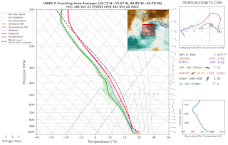 |
HWRF mean sounding on 18z October 23, showing a stout MSE minimum aloft
|
It appears that the guidance's expectation that Otis would remain weak hinged on Otis being unable to break this lid. However, the placement of Otis's convection would rapidly swing things in the storm's favor. Otis had been preferentially firing deep convection off on its western side. While the upper-level winds near the outflow layer pushed these storms west away from Otis's center, the westerlies at 400-600 hPa did the opposite. As these updrafts grew and decay, detrained cloud droplets and precipitation would have been advected east over the center of circulation. Any evaporation of this detraining mass flux would have led to cooling aloft in the 400-600 hPa: directly over the capped convection and precisely at the mid-tropospheric moist static energy minimum. It's my conjecture that, eventually, enough destabilization occurred aloft from this efficiently placed detraining moisture that the lid was broken, allowing for Otis's core to axisymmetrically erupt on the night of October 23 and setting up an extreme intensification the following day that led to Otis's Category 5 intensity. Additionally, the westerly flow aloft relaxed and sea surface temperatures increased from 29C to 31C around the time that this lid was broken, which appears to have occurred after 00:00 UTC on October 24. These factors appear to have aided Otis's intensification and made the environment dramatically more conducive for rapid intensification during the course of that day.
Even with all of this in mind, I think that the magnitude of extreme intensification of Hurricane Otis would still be missed with our modern forecast aids, slipping past all explicit and probabilistic model guidance. However, I think there is value in reasoning about how such a significant event avoided detection until essentially the very last moment.
Regarding what I've conjectured to be building blocks in setting up and enabling Otis's unexpected rapid intensification, here are what I think are the key points:
- For 1-2 days, Otis's vortex was restricted to below 600 hPa. This may have been associated with a low theta-e layer aloft, possibly reinforced by negative moist static energy advection from the Gulf of Mexico during Otis's early stages.
- Otis's stumpy vortex avoided strong wind shear aloft, and the focusing of latent heat release in this somewhat deep but low-level layer efficiently strengthened the vortex and stockpiled moist static energy
- Otis's propensity to fire deep convection north and west of the center of circulation was favorably positioned for westerly flow at 400-600 hPa to advect moisture from these updrafts directly over the center of circulation and the low-level core. This MSE advection occurred at the mid-tropospheric MSE minimum and directly above Otis's capped convection, inducing destabilization aloft.
- The combination of destabilization aloft from repeated convective detrainment and warming sea surface temperatures eventually led to a collapse of the lid and a significant increase in convective vigor and storm intensity on the night of October 24-25.


